Landscape Planning Studio

TEMPERATURE
No precise local climatic records are made, as the study area lies on the boundary between Al-Bahah and Makkah regions. We have depended on Al-Bahah's climate station from 1987-2007, as it is the nearest.
The climate around Jabal Batharah is fairly warm in summer and relatively cold and damp in winter. During winter and spring it is often rainy and cloudy on the escarpment edge.
OROGRAPHIC RAIN
PRECIPITATION
The annual rainfall ranges between 400 mm on the escarpment to under 200 mm to the east of Jabal Batharah. There, except for lower rainshadowed slopes, it always exceeds the low average evaporation rate. 60% of this precipitation falls between December and April. Hail is not unusual. The escarpment edge and mountain top are affected by the convection of humid air from the Red Sea which is channeled up the wadis and the escarpment by the prevailing westerly winds; also by convective turbulence created over the rough vegetated terrain, They may be cloud-covered, windy and cold while less than ten kilometers to the east in the rainshadow of Jabal Batharah it will be sunny, warm and dry.

CONDENSATION
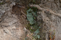
The highest land, over 2,000 meters, is the wettest, and the north and west-facing slopes being cooler and damper than those facing the south and east, as a result favoring tree growth and agriculture. This is a zone where condensation, especially on trees, may equal the precipitation from rainfall, and which still supports a cloud-contact woodland in areas which have not been cleared for timber. Local people report that 70 years ago, before the large scale cutting of trees for construction, summers were cooler and wetter. This zone is between 3.5-4 kilometers wide at the scarp edge and 6 kilometers wide at Jabal Batharah which extends the orographic effect of the escarpment.
Condensation
Zone
Rainshadow

Orographic uplift;
warm, moist air cools as it rises
Prevailing Wind
Clouds form as
vapor condenses
Cool, dry air
warms as it descends
Waterbody
Click the link below & zoom in and out to view the formation of clouds due to the orographic uplift via satellite imagery!

HUMIDITY
The average monthly maximum humidity does not go below 95% in the summer and reaches 100% in the winter. The minimum monthly average does not exceed 8%. The average humidity ranges between 34% and 60% through the year.
WIND ROSE
The prevailing regional wind (al-Adali) comes from the west and southwest bringing clouds and rainfall over the scarp in winter and spring, and regularly on summer afternoons, often accompanied by thunderstorms. In summer, a dry wind (as-Saba) blows from the southeast. Mountain winds are complex, being channeled and deflected by the topography, with a diurnal pattern of evening down-valley and morning up-valley winds.


WINDS
For seven kilometers Jabal Batharah rises parallel to and 500m above the escarpment and surrounding ridges. It channels descending currents of cool humid air down the valleys so that junipers grow even at low valley mouths in W. Aradah and W. Kid surrounded by drier hillsides. Air turbulence in the lee of the massif probably intensifies the effect of its rain-shadow and the rising currents of air lead to the formation of hail: in late March 1997, a severe hailstorm flattened crops and damaged cars with stones of over 200 grams in weight.

GENERAL MICRO-CLIMATE MAP

RAINSHADOW
SUB-HUMID ZONE
SEMI-ARID ZONE
condensation zone
jo formation

CLIMATE


GEOLOGY
GEOLOGY
MAP
basalt and dacite
alluvial deposits
ras formation
biotite hornblende granite
biotite schist, hornblende schist,
amphibolite
jo formation
faults
SYNOPSIS
Jabal Batharah is a pale gray pluton of alkaline quartz monzonite surrounded by metasedimentary and metavolcanic rocks (biotite schist, greywacke and phyllitic quartzite, and meta-basalt) inter-layered in north-south trending folds and faults. The beds of Wadi Turabah, Wadi ‘Aradah, and Wadi al-‘Usbah are composed of alluvial gravel and silt.
The geology of the area is dominated by the high white monzogranite pluton of Jabal Batharah above the escarpment north of which rise knobbly highlands of darker granite; superimposed on a country of north-south trending ridges and valleys formed in varieties of schist.
THE SCHIST RIDGES
Below and east of Jabal Batharah, metasedimentary and metavolcanic rocks are interlayed in a ridge and valley landscape formed by steep north-south trending folds and faults. The ridges are formed of rock resistant to erosion and the valleys of nonresistant rock weathered along fault lines. The rocks are primarily amphibolite schist (bga) which forms the escarpment, greywacke, phyllitic quartzite (bhr) and biotite schist (bha). Weathering of the dipslope has formed the fertile valleys of Wadi Mahwah and Wadi as-Sayilah behind and parallel to the scarp, and in the foothills of the granite massif, radial valleys and ridges, mostly in the more erodible schist, have weathered into more rounded hills sectioned by felsic dykes. The dominant Wadi Turubah drainage has incised steep sided meanders due to past erosion which has kept pace with uplift.


These rocks have shapes similar to those of nearby Jabal Batharah's granite.

Granite pluton visible behind the southern schist.

Steep sided meandered schist surrounding Wadi Turubah
ALLUVIAL DEPOSITS
In the wider reaches, there are 2-3 meter high wadi terraces of fertile silt, as well as deep alluvial gravels. Where floodprone, shallow gravelly rock-covered soils form grassland in valleys east of Jabal Batharah. They are good rangeland usually overgrazed where accessible. In Wadi Turubah the floodway covers most of the valley floor and the alluvial gravels are covered by waterborne pebbles and rocks. The only mining activity in the study area is for roadstone. Stone dumps exist at the mouth of Wadi Kid and Wadi at-Taraf, and quarries beside the mouths of Wadi Kid and Wadi Shumrukh.


An alluvial narrow stream, part of Wadi Shumrukh

Waterborne pebbles and rocks covering the alluvial gravels due to floods.

Floodprone shallow gravelly rock-covered soils form grassland in Wadi Turubah.
MONZOGRANITE HIGHLANDS
The silver-grey granite pluton of Jabal Batharah outcrops almost on the edge of the Sarawat escarpment, part of the mountain system of the Red Sea rift. It is about 7 x 7 kilometers round and is formed of alkaline medium-grained quartz monzonite (gmp). Quartz is present in significant amounts. Biotite and/or hornblende constitute the dark minerals. Because of its coloring, it is often confused with granite, but whereas granite contains more than 20% quartz, quartz monzonite is only 5–20% quartz resulting in the name Monzogranite. The large boulders of Joshua Tree National Park in southern California are quartz monzonite.
It is split by a fault which has eroded to form the valleys of Wadi Kid. The mountain rises 500-600 m above the surrounding ridges in the castellated massif of domes, pinnacles and cliffs, with a talus of massive boulders on the upper slopes derived from the large scale vertical and horizontal jointing of the rocks. The knobbly highlands of the upper Wadi Shuqub are also granite, formed of resistant granitic diorite with tonalite (td) and biotie quartz.


The large silver granite dome of Tanah (تانة) is displayed.

The human-scale compared to the size of boulders is evident

The contrast between Jabal Batharah's monzogranite pluton and the adjacent schist ridges is obvious.
FORMATION
Figure 1
The monzogranite developed a system of rectangular joints. One set, oriented roughly horizontally, resulted from the removal—by erosion—of the miles of overlying rock, called gneiss (pronounced “nice”). Another set of joints is oriented vertically, roughly paralleling the contact of the monzogranite with its surrounding rocks. The third set is also vertical but cuts the second set at high angles. The resulting system of joints tended to develop rectangular blocks. (figure 1)
Figure 2
As ground water percolated down through the monzogranite’s joint fractures, it began to transform some hard mineral grains along its path into soft clay, while it loosened and freed grains resistant to solution. Rectangular stones slowly weathered to become spheres of hard rock surrounded by soft clay containing loose mineral grains, like holding an ice cube under the faucet. The cube rounds away at the corners first, because that is the part most exposed to the force of the water. A similar thing happened here but over millions of years, on a grand scale, and during a much wetter climate.
Figure 3
After the arrival of the arid climate of recent times, flash floods began washing away the protective ground surface. As they were exposed, the huge eroded boulders settled one on top of another, creating those impressive rock piles we see today.
Joshua Tree National Park in California consists of the same exact monzogranite rocks as Jabal Batharah. Click the link below to watch how Joshua Tree's rocks were formed.


Rock Drainage
CONTRIBUTION TO
PLANT LIFE
The monzogranite of Jabal Batharah is composed of massive non-porous monzogranite. It literally sheds every drop of water that lands on its surface within its fissures and colluvial skirt to the soil formed beneath and thus heavily contributing to plant life within the mountains grounds.
In the adjacent video, we have mixed ink with water and poured it on a rock acquired from Jabal Batharah to demonstrate the non-porous rocks and its ability to shed 100% of the precipitation fallen on it.

PHYSIOGRAPHY
SYNOPSIS
The granitic pluton of Jabal Batharah forms a mountain massif on the edge of the Sarawat Escarpment, rising 600 meters above the adjacent hills and 2000 meters above the Tihamah foothills below the Sarawat Escarpment. Eastward, the metamorphic hills form a ridge and valley landscape with ridges of resistant rock and valleys weathered along fault lines, across which Wadi Turabah is diagonally incised. Both of Wadi ‘Aradah and Wadi Turabah have incised steep sided meanders.


Visually and in character, Jabal Batharah is one of the greatest mountains of Arabia. It is known locally as Jabal Ibrahim or Jabal Abyad (The White Mountain). It’s crown of more than 20 peaks and pennacles, domes and castilated cliffs of silvery gray brown granite rises 1,000 meters above its adjacent wadi floors.

VIEWS
The nearby ridges often obscure the view, but from the north on the escarpment highway the mountain is visible far down Wadi Mahwah, and as it approaches the col between Makkah and Al-Bahah provinces the road swings dramatically under the massive exfoliation dome and wall of the southwest face. The mountain is so large and irregular that it has numerous small valleys, pinnacles and cliffs, and many partial views of buttresses and walls over a valley or ridge. But there are only a few viewpoints of the whole massif: from the south of Al-Baw on the Al-Bahah road; from the north from the old Haddad track above At-Taraf, and from the east from the entrance of Wadi Kid, which once a charming valley of rocks, meadows, and river palms which has been degraded by development a long while ago.
ELEVATION
The wadis surrounding the mountain are enclosed and of varying characters. Most of the mountain's radial valleys begin in neat basins of farmland, boulder slopes and cliffs. But a track out of Wadi Kid and a path above the hamlet of 'Adhir lead to a bowl of high green meadows around the abonded village of Widd in the heart of the mountain. Peaks circle the meadows. Above them, amongst huge boulders, hang dense remnant juniper woods and the rarified upper zone of rock which harbors relict communities of palaearctic plants. Compared with the degraded wadis and overgrazed hillsides below, it is another world.

Jabal Batharah
Wadi Turubah
 |  |  |
|---|

To its west, between the escarpment dipslope and the foothill ridges of Jabal Batharah is the wide well populated Wadi As-Sayilah, culminating in a col 600 m below the summit and 1,500 meters above the Tihamah plain, over which the escarpment highway runs. It is obvious that in the entire study area, farms only exist on slopes less than 5%.
ASPECT
The highest land, over 2,000 meters, is the wettest, slopes facing north and west being cooler and damper than those facing the south and east, as a result, these aspects favor tree growth and agriculture of multiple fruits and mainly pomegranates.


Western-facing slopes are more prone to precipitation
Abu Khazma al-Kabeer أبو خزمة الكبير peak seen from the southern side.

Steep sloped granite boulders are favorite for adrenaline pumping rock-climbing

SYNOPSIS
With a watershed of over 7,000 square kilometers and 9% of the country’s internal drainage, Wadi Turabah is one of the most important watercourses in the Kingdom; upstream of its confluence with Wadi ‘Aradah, Wadi Turabah is known as Wadi Turabah az-Zahran. The most important tributaries of Wadi Turabah in the proposed reserve are Wadi ‘Aradah, with its tributary Wadi Kid, and Wadi al-‘Usbah. From the east side of Jabal Batharah, the perennial stream of Wadi Turabah flows perennially for more than 20 km to Wadi al-‘Usbah. Wadi ‘Aradah below Al-Aghwar and the lower part of Wadi Kid also contain perennial streams.
Wadi Turubah drains some 140 kilometers of escarpment farmland, from Raghdan to beyond Maysan, 70 kilometers north of Jabal Batharah. Most of this area has an average rainfall of between 300 and 400 mm. Drainage from the valleys west and northwest of Jabal Batharah combine with the flow from the mountain into one of the very few long wadis in the Kingdom with permanently flowing water, which runs for between 20 and 30 kilometers. Its watershed above the town of Turubah is over 7,000 sq. km. in area. It includes the flow from eight major tributaries and contributes 9% of the country's internal drainage.
E
D
C
B
-A
Together, these make up one of the Kingdom’s longest perennial streams and biologically richest wetlands. The water is well oxygenated but very alkaline. The Municipality of At-Ta’if used to extract some 14,000 cubic meters of water daily from Wadi Turabah almost until the year 2000, and the local people blame this draw-down for the lowering of the water table.
A
From Wadi Turubah az-Zahran which originates 60 km south and takes the drainage from several streams off the mountain before Wadi Turubah.
B
From Wadi As-Sayilah west, and Wadi Mahwah northwest of Jabal Batharah which combine to form Wadi 'Aradah which skirts the north and northeast sides of the mountain. Nine kilometers directly behind the scarp and six above the confluence with Wadi Turubah, where the pluton intersects the wadi, the permanent stream begins, where the granite dams the wadi's subsurface flow, forcing it to the surface.

C
From valleys radiating from the west, north, and north-east flanks of Jabal Batharah, which drain into the Wadis as-Sayilah from 'Aradah. These include the large basin of Wadi Kid which has a small permanent flow.


D
From the southwest cliffs of the mountain which drain directly over the escarpment.


E
From ten main tributaries between the Wadi Aradah and the Taif - Al-Bahah road, where the municipality of Taif drew off water for Al-Hada and Taif.

 |  |  |
|---|

HYDROLOGY

SILTY-SANDY
LOAM
SCHIST
LITHOSOLS
MONZO-GRANITE
DERIVED
SOILS
WADI SOILS
PEDOLOGY
SCHIST LITHOSOLS
Skeletal soils on steep rocky slopes that are derived from schist have poorer nutrient and water-holding qualities than the granite, resulting in less vegetative cover. On the smoothly weathered fast-draining metamorphic ridges these soils are very shallow and barren except in valley bottoms, which are unsuitable for farming, and are poor rangeland. On the wet vegetated edge of the escarpment however, a small percentage is suitable for terraced farming and it supports fair rangeland.
WADI SOILS
In the wider reaches, there are 2-3 m high terraces of fertile silt, as well as deep alluvial gravels. Where floodprone, shallow gravelly rock-covered soils from grassland in valleys east of Jabal Batharah. They are good rangeland usually overgrazed where accessible. In Wadi Turubah the floodway covers most of the valley floor and the alluvial gravels are covered by waterborne pebbles and rocks.


MONZOGRANITE-DERIVED SOILS
On Jabal Batharah, fertile colluvial silt is concentrated behind rock sills in several basins large enough to hold small farms, in pockets between cliffs and boulders and in wadi sides along the foot of mountain slopes. These soils derived from granite and formed under former woodland are among the most fertile in the country. They are moderately deep, loamy, non-saline and alkaline, with high water retention and supply sufficient plant nutrients and water for patches of dense vegetation where the land is too bouldery for farming or grazing except in the basins.
West of Jabal Batharah wadi soils partly derived from granite are found in the wide fertile valleys behind the escarpment, reduced to alluvial terraces in the flood-prone Wadi ‘Aradah. The terraces are of silt from 2-3m thick, and were long-wooded with juniper and later farmed in the wetter highlands as the soil has become loam. Intensive tree-cutting in the past has however decreased the productiveness of these soils whose conservation is vitally important.

SOIL SAMPLES
Salt %
7.8
7.6
8.1
7.8
7.3
0.51
0.48
0.47
0.49
0.51
SAMPLE SITE
SOIL
TYPE
ORGANIC MATTER %
WATER
CONTENT %
pH
Wadi Aradah Terrace
Hima Rudmah Hillside
Adhir Basin
Adhir-Widd Hillside
Widd Meadow
Silty Loam
Silty Loam
Sandy Loam
Silty Loam
Silty Loam
2.5
2.0
2.1
2.0
1.9
0.71
1.38
1.40
0.32
1.33
SOIL FORMATION
Monzogranite derived soils are formed by different forms of weathering, which are illustrated below.
 Biological Weathering by Lichens |  Biological Weathering by Roots |  Biological Weathering by Fissures |  Physical Weathering by Erosion |  Physical Weathering by Cracks |
|---|---|---|---|---|
 Chemical Weathering by Hydrolysis |

PEDOLOGY

VEGETATION
POTENTIAL PLANT DISTRIBUTION
SYNOPSIS
The vegetation of the study area is divided into two basic types: mountain and wadi floor, these can be sub-divided by elevation, water availability, density, rock & soil type and plant associations into 4 sub-divisions, Juniperus groups, Evergreen Woodlands, Semi-Arid Sudano-Zambezian Region, and Wadis.


PALAEARCTIC FLORA
The highest area is a small survival of palaearctic relict vegetation on the cool, humid, inaccessible rocky topmost 150-200 meters of Jabal Batharah. It has been visited by helicopter and recorded by the eminent field botanist Mrs. Sheila Collenette. Her checklist for the mountain given in the Checklist of Plants on Jabal Ibrahim contains several endemic species and several others such as Erica arborea (tree heather) found only in similar high mountain terrain in Arabia and in the Mediterranean. The main tree is Juniperus procera.


Juniperus procera - Olea europea GROUP
In the cloud-contact zone, the dominant trees are Juniperus procera, with sub-dominants Olea europea and Barbeya oleioides and a rich shrub layer. Other trees include Pistacia falcata, Acacia origena, Euclea schimperi, Trema orientalis, and where there is water, Salix mucronata. Large shrubs include Rhus rhetinorrhea, Sageretia thea, Cluytia mycricoides and on dryer slopes, Dodonea angustifolia. Dominant smaller shrubs are Psiadia punctulata, Lavendula dentata, Otostegia fruticosa, all good sources of nectar for honey, and Aerva javanica. Ruta chalepensis and Achillea biebersteinii are prominent flowering herbs, and the dominant grasses. It is the main vegetation unit in the high areas above 2000m. This zone is recognized by a high total coverage of 80%. The soil beneath this diverse wealthy layer is quite developed and the soil litter layer can always be recognized. The tree stratum mostly reaches a height of 10m ranging between 40-60% with high cover abundance, the shrubs stratum reaches a height of 2 meters and coverage of more than 30%, the ground layer cover is very dense not falling below 60%. This group represents the sub-climax vegetation in this study area.


Juniperus procera - Acacia origena GROUP
It spreads in the same altitude (>2000m). The soil is also developed and the litter layer could be seen. In fact, this group is recognized by the total coverag with a low abundance, and the tree stratum not exceeding 40% with Acacia origena as the main tree that shares Juniperus procera forest. The components of this group and in particular the arboreal stratum, are liable to disappear and hence the ground cover will decrease, where the arboreal density of juniper and acacia as well as several accompanied species is decreasing.


DEGRADED JUNIPER WOODLANDS
That paves the way for other species of a degrading indication to appear and increase which will cause the dominance of another vegetation component that has an indication of deterioration. It is a sign of a disturbed situation of the Juniper forest when the human activities increase. This leads to a change of vegetation structures especially with the disappearance of most of the arboreal stratum and changes to the ground cover and shrubs stratum. Juniper woodland can still be seen in sheltered north-facing valleys, but tree cutting for construction in the cities within the last 50 to 60 years has decimated what was said to have been a thick woodland. One stump seen in Wadi Kid measured 75 cm across. Many surviving junipers are small and are too widely spaced and grazed round to allow the recovery of the density needed for the succession of young trees. Except within the condensation zone, junipers are found mainly on granite rather than on schist.


Olea europea - Dodonea angustifolia GROUP
The coverage is highly affected by slope; it consists of many annual and perennial species that shared Juniper forest in the height. It is spread in a zone between 1,800 and 2,000 m. These are warmer, less humid and more grazed than the upper slopes: near water they may be overgrazed. The dominant trees on the granite in the sub-humid area are Olea europea and Acacia origena. There are some Pistacia falcata trees, in hillside wadi beds, and (though not on Jabal Batharah) Nuxia oppositifolia. On slope-foot seeps, Ficus ingens and Ficus cordata salicifolia are frequent. Almond and pomegranate grow well in the colluvial basin farmlands. Dodonea angustifolia is the dominant large shrub with Rhus rhetinorrhea, Sageretia thea and Carissa edulis. In places the very handsome blue Plectranthus asirensis is common. Psiadia punctuata with Otostegia fruticosa, Lavendula pubescens and Pulicaria undulata are dominant small shrubs, Hypoestes forskalii a dominant herb, and Hyparrhenia hirta is the dominant grass.


Rhus retinorrhea-Pistacia falcata GROUP
At the higher escarpments, (1,600-1,800m) the vegetation consists of evergreen vegetation that belongs to Olea, Ficus, Rhus and Pistacia species, while at the lower escarpments, where the elevation is less than 1600m, the vegetation is dominated by semiarid Acacias as a transition group into the next zone. After that, the vegetation changes dramatically in Tihamah being replaced by a different vegetal composition consisting of arid Acacia vegetation, which consists of Acacia ehrenbergiana, Acacia etbaica and Acacia tortilis.


Acacia SEMI-ARID REGION
Schist slopes in the semi-arid area are almost bare of trees and large shrubs except in drainage ways and seeps, which have a sparse vegetation similar to that of the humid slopes, mainly acacia scrub. Near permanent water they are severely overgrazed to 150-200 meters above the wadi floor. In the lower reaches of Wadi Turubah, Acacia asak replaces Acacia origena, and Moringa peregrina is quite common on the lowest slopes above the wadi.


Acacia gerrardii - Zizyphus spina-Christi GROUP
Wadi floors in the sub-humid and semi-arid zones which are not scoured by floods are grassy and drastically overgrazed by stock, including cows and feral donkeys. Only a lifetime ago these valleys are said to have been thickly wooded. Almost the only plants now left to hold the soil are poisonous or unpalatable, such as Withania somnifera, Solanum incanum and the invasive Mexican poppy, Argemone ochraleuca. There are still groves of large but old Acacia iraqensis and Zizyphus spina-Christi in Wadi Aradah, with Ficus ingens and Ficus cordata salicifolia at seeps in the cliff-foot rocks. One very decorative tree dominant in Wadi Kid and found on the terraces of Wadi Aradah is Phoenix caespitosa, which usually occurs in dense groves. If the wadi were less grazed, Lycium shawii and the tall grass Saccharum spontaneum would be more evident.


Rhus retinorrhoea - Ficus salicifolia-fisal GROUP
In the condensation and sub-humid zones, where valleys are fertile and well farmed with less intensive grazing, the dominant native trees are juniper, olives and Acacia iraqensis and Barbeya oleioides. These are supplemented by Ficus palmata and Zizyphus spina-christi especially towards the dryer east. At cliff-foot seeps, Ficus cordata salicifolia-fisal and Ficus ingens are common. The main shrubs are Rhus retinorrhea, Rumex nervosus, large bushes of which grow along terrace walls, Ricinus communis, Pulicaria undulata and Solanum incanum. In some places Buddleya polystachya is common. In addition, the vegetation structure at watercourses on Wadis is affected by the attitudinal gradient. It can be seen that the upper-stream vegetation has RrFsG at the escarpments, then the vegetation of the watercourses on Tihamah province changes to ZsG, which is largely shared by Acacia tortilis.


SUMMARY
The potential distribution of natural vegetation in our obviously diverse study area is summarized in the section below.
Note: Scale of trees is enlarged 250 times.

SYNOPSIS
Similar to the flora, the wildlife of the study area is diverse, includes multiple endemic species, and is under threat from the local population's expansion. It is concentrated in three main zones: the summits of Jabal Batharah, the freshwater streams, and the remote ridge and valley country on either sides of Wadi Turubah.

POTENTIAL ANIMAL
DISTRIBUTION
AVIFAUNA
Jabal Batharah / Wadi Turabah supports the globally threatened Yemen thrush Turdus menachensis (breeding), imperial eagle Aquila heliaca (passage migrant), and corncrake Crex crex (passage migrant).
The site is listed as an Important Bird Area on the basis of
1.
Criterion 2i (regularly holds 1% or more of a species’ biogeographical or flyway or Middle Eastern population);
2.
Criterion 3 (regularly holds a significant number of a species that is threatened or declining within the Middle East): bittern, Egyptian Vulture Neophron percnopterus, Griffon Vulture Gyps fulvus, Lanner Falcon Falco biarmicus, and Montane Nightjar Caprimulgus poliocephalus;
 Egyptian Vulture |  Griffon Vulture |  Lanner Falcon |  Montane Nightjar |  Eastern Imperial Eagle |
|---|

Scientific Name: Alectoris philbyi Status: Least Concern Population trend: stable

Scientific Name: Alectoris melanocephala Status: Least Concern Population Trend: stable

Scientific Name: Dendropicos dorae Status: Near Threatened Population Trend: decreasing

Scientific Name: Oenanthe lugentoides, Status: Least Concern Population Trend: stable

Scientific Name: Onychognathus tristramii Status: Least Concern Population Trend: stable

Scientific Name: Estrilda rufibarba Status: Least Concern Population Trend: decreasing

Scientific Name: Serinus rothschildi Status: Least Concern Population Trend: stable

Scientific Name: Serinus menachensis Status: Least Concern Population Trend: stable

Scientific Name: Linaria yemenensis Status: Least Concern Population Trend: decreasing

Scientific Name: Turdus menachensis Status: Near Threatened Population Trend: decreasing

Scientific Name: Crex crex Status: Least Concern Population Trend: stable
3.
Criterion 4 (regularly holds a significant number of a species whose world population is wholly or largely restricted to the Middle East): among others, Philby’s partridge Alectoris philbyi, Arabian partridge Alectoris melanocephala, Arabian woodpecker Dendrocopos dorae, Arabian wheatear Oenanthe lugentoides, Tristram’s grackle Onychognathus tristramii, Arabian waxbill Estrilda rufibarba, Arabian serin Serinus rothschildi, Yemen serin Serinus menachensis, and Yemen linnet Carduelis yemenensis;
4.
Criterion 5i representative example of a habitat associated with a characteristic assemblage of bird species; and
5.
Criterion 5ii rare / threatened / unique habitat associated with a characteristic assemblage of bird species.
6.
Criterion 6 (site important for bird conservation through education / research / tourism).

The current bird list contains 123 species (Cf. Newton, S.F., A. V. Newton, and H. Winkler, Fauna vol. 14), including residents and migrants. The site’s location and mix of habitats provide an avifauna with Afrotropical elements. The permanent water and rich associated vegetation attracts a wide variety of passerine passage migrants. It is also a breeding area for 12 of the 24 resident species of raptors in the Kingdom, including Verreaux’s eagle Aquila verreauxii and Bonelli’s eagle Hieraaetus fasciatus. There are resident populations of hamerkop Scopus umbretta (c. 30 birds) and grey-headed kingfisher Halcyon leucocephala, as well as a wintering population of up to 20 black stork Ciconia nigra. Eight of the 13 species endemic or near-endemic to the southwestern highlands of Arabia occur, as well as Bruce’s green pigeon Treron waalia and amethyst starling Cinnyricinclus leucogaster. Breeding birds also include little rock thrush Monticola rufocinereus, brown woodland-warbler Phylloscopus umbrovirens, and cinnamonbreasted bunting Emberiza tahapisi. Hoopoes, unexpectedly, are also common.
 Verreaux's eagle |  Bonelli Eagle | 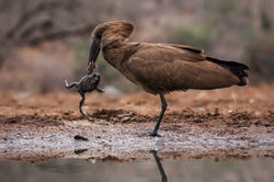 Hamerkop |
|---|---|---|
 Grey-headed Kingfisher |  Overwintering Black Storks |  Bruces Green Pigeon |
 Violet Backed Starling |  Little Rock Thrush |  Brown Woodland-Barbler |
 Cinnamonbreaster Bunting |  Hoopoe |
SURVEY SECTIONS, HABITAT TYPES & KEYS
TO THE ABUNDANCE OF THE
BIRDS OF WADI TURUBAH
from Newton, S & A. & Winkler, H. "The Avifauna of Saudi Arabia"
in Fauna of Saudi Arabia, Vol. 14.

3. Wadi
Turubah C
4. Wadi
Aradah
6. Wadi Mahwah
7. Wadi
As-Sayilah
5. Wadi
Keed
1. Wadi
Turubah A
2. Wadi
Turubah B
Habitat types within each section:
A: Generally Absent B: Scarce C: Common
Habitat
Abbreviation
Section 1
Section 2
Section 3
Section 4
Section 6
Section 5
Section 7
ii. Fluvial Terraces
Vegetated/bushy
Gravelly
Sandy/Grassy
iii. Woodland/Trees
Acacia woodland
Riparian woodland
Scrub woodland
Montane woodland
Cliffs and caves
Hill tops
Vegetated rock slopes
Barren rocky slopes
Granite boulders
v. Rocky Habitats
Dry wadi bed
Stagnant pool
Flowing wadi
Stream
Aquatic vegetation
i. Wetland/Wadi
(Wa)
(WaD)
(WaP)
(WaF)
(WaS)
(WaV)
(T)
(TV)
(TG)
(TS)
(WO)
(WoA)
(WoR)
(WoS)
(WoM)
(R)
(RC)
(RH)
(RV)
(RB)
(RG)
(H)
(HC)
(HB)
(HG)
(HF)
C
A
B
A
A
A
C
A
A
A
B
A
B
B
B
C
A
C
C
A
B
B
B
C
B
C
B
C
C
A
B
B
A
C
C
C
B
A
C
A
A
A
B
B
C
B
C
B
C
C
A
B
B
A
C
C
C
B
A
C
A
A
A
A
B
C
C
C
C
A
C
C
C
C
C
C
C
C
B
C
C
B
A
B
B
B
B
A
B
C
B
C
C
B
C
A
B
C
C
B
B
C
B
B
C
C
A
A
A
A
C
B
B
C
B
B
A
B
C
C
B
A
B
C
C
C
A
B
A
C
B
A
A
A
A
C
A
C
C
C
C
A
C
A
B
B
C
Camps (villagers)
Buildings (permanent)
Gardens
Fields/Terraces
v. Human Habitats

iv.
AQUAFAUNA
The second most detailed report on the area is on the freshwater fishes of Wadi Turubah by Schulz et al. This list contains three endemic species: Cyprinion mhalensis, Garra buettikeri (vulnerable), and Barbus apoensis found in 1990 in six sample plots, which we have verified during a site-visit. The stream is both narrow and shallow, flowing over sand, pebbles and boulders, and varies from fast to still, with dense algal mats in the shallows. It is very alkaline (pH: 7.75-9.0), well oxygenated and not very varied in ecological character. When last studied it was polluted in one place by ammonia from livestock faeces, and the team saw two pools devastated by bilharzia-hosting snail pesticide.
All three species of fish are generalists. According to Dr. F. Krupp, the larger fish of all three species are several years old, surviving the summer in pools and crevices; most fish die in summer but the larger numbers produced make up for this. Large schools of Cyprinion were seen by the SWA team, the largest about 100-120 mm, mixed with Garra, of similar size. No live Barbus which can reach a size of 150 mm was seen, but several dead ones (250 x 9 mm) in size were found at Al-Aghwar and near the mouth of Wadi Kid. Officials from the Ministry of Health of Taif had two days previously, in face of local protests, dumped bilharzia-host snail pesticides in these two pools. The fishkill was total but appeared not to affect fish immediately downstream. Six weeks later these pools appeared to have recovered.


Cyprinion
Water level before summer & algal bloom
Shepherds

FISHING
Another threat comes from fishermen. The shepherds do occasionally eat the fish which they say are good, and the team saw two netting expeditions, a group of Indian expatriates with buckets full of Cyprinion, the one of local children using both, a float net and rod. Electrofishing has also been reported. Toads were often seen, and the water seems to support a rich aquatic life. Baletto et al. lists two species almost certainly to be found on site. And in Wadi Kid in rock pools, at about 1,940 m, large 100 mm grey brown speckled tadpoles were seen which resembled a description in Baletto of Euphlyctis ehrenbergii. Again according to Dr. Krupp, the area is also important for rare and endemic species of dragonflies (Odontata).
Garra
Water level during summer & algal bloom

SUMMER AND ALGAL BLOOMING
Warm water holds less dissolved oxygen than cold water, so summer is the time when fish can have a hard time getting enough oxygen. Other organisms use oxygen, too, including the algae that grow in the summer and bacteria that degrade organic matter. During the day, the algae produce oxygen through photosynthesis, but at night, when photosynthesis stops, they and other organisms keep respiring, using up oxygen.
So on warm summer nights during algal blooms, the dissolved-oxygen concentration sometimes drops too low for the fish, and a die-off can occur. This can occur as a result of purely natural conditions or because of human activity that results in adding nutrients, nitrogen and phosphorus, to water systems.


100% Energy
10% Energy
1% Energy
0.1% Energy
4th Trophic Level
3rd Trophic Level
2nd Trophic Level
1st Trophic Level
MAMMALS
"كل ما خلق ربّي موجود في هالجبل, الّا الأسد"
Jabal Batharah is half surrounded by intensive farming and half by large flocks of livestock, which put increasing pressure on the existing wildlife except for species commensal with man: during the team's brief surveys, the most evident wild mammals seen were dead ones. But above the 1,900-2,000 m level the inaccessibility of the peaks, the climate, the topography and the mountain's height have preserved a unique island of ecological diversity about 25 sq. kilometers in area.
The mammals of Jabal Batharah include baboon, Arabian wolf Canis lupus arabs, striped hyaena Hyaena hyaena sultana, caracal Caracal caracal schmitzi, rock hyrax Procavia syriaca, Indian crested porcupine Hystrix indica, unidentified jirds, and according to local people, wildcat Felis silvestris, genet Genetta genetta granti, ratel Mellivora capensis pumilio, Arabian hare Lepus capensis arabica, and desert hedgehog Paraechinus aethiopicus. Local informants have also reported observing Arabian leopard Panthera pardus nimr both on Jabal Batharah and near the confluence of Wadi ‘Aradah with Wadi Turabah in recent years. Hoary fox Vulpes cana may also be found and Harrison and Bates list several species of bats in the region. The site appears suitable for the reintroduction of Nubian ibex Capra (ibex) nubiana and mountain gazelle (idmi) Gazella gazella.
 Hamadrayas BaboonScientific name: Papio hamadryas Status: Least Concern Population trend: Decreasing |  Striped HyaenaScientific name: Hyaena hyaena Status: Near threatened Population trend: Decreasing |  CaracalScientific name: Caracal caracal Status: Least Concern Population trend: Unknown |
|---|---|---|
 Rock HyraxScientific name: Procavia capensis Status: Least Concern Population trend: Stable |  Indian Crested PorcupineScientific name: Hystrix indica Status: Least Concern Population trend: Stable |  King JirdScientific name: Meriones rex Status: Least Concern Population trend: Unknown |
 WildcatScientific name: Felis silvestris Status: Least concern Population trend: decreasing |  GenetScientific name: Genetta genetta Status: Least Concern Population trend: Stable |  Honey BadgerScientific name: Mellivora capensis Status: Least Concern Population trend: Decreasing |
 Arabian HareScientific name: Lepus capensis Status: Least Concern Population trend: Decreasing |  Desert HedgehogScientific name: Paraechinus aethiopicus Status: Least Concern Population trend: Stable |  Arabian LeopardScientific name: Panthera pardus nimr Status: Critically Endangered C2a(i) Population trend: Decreasing |
 Hoary FoxScientific name: Lycalopex vetulus Status: Least Concern Population trend: Unknown |  Geoffroy's BatScientific name: Myotis emarginatus Status: Least Concern Population trend: Stable |  Nubian IbexScientific name: Capra nubiana Status: Vulnerable C1+2a(i) Population trend: decreasing |
 Mountain GazelleScientific name: Gazella gazella Status: Endangered A2acd Population trend: Decreasing |
Leopards used to be seen before the escarpment road was built. They are now rare, but were reliably reported to the SWA: one above Widd, and one above Wadi Aradah confluence. During our visit, an old man in Wadi Kid has ensured us that they exist on Jabal Batharah, and he claims that during winter time, they could be seen descending down the escarpment to the Tihamah plains, where it is much warmer.
Wolf, hyaena, and caracal, seen mainly to the north of Wadi Turubah, were described as common, and carcases of each were seen by us and the SWA team hanging on trees. A wolf was said to have recently taken seven sheep east of the mountain and one has been found with fish in its belly. Scarecrows set up against fruit-stealing baboons - which are common but not yet commensal - (at Adhir) and wolves were seen.


REPTILES,
AMPHIBIANS
& INVERTEBRATES
Lizards and snakes known to inhabit the proposed protected area include Acanthocercus adramitanus and Acanthocercus yemenensis, and the Arabian cobra Naja haje arabica. At least four other species of snakes are listed by Gasperetti in the region.
The amphibians have not been inventoried, but the site supports the Arabian toad Bufo arabicus and probably the Oman toad Bufo dhufarensis, which is found in Wadi Buwah to the north and also south of the site; the European green toad Bufo viridis is also likely to occur. It supports the Middle East tree frog Hyla savignyi, and is believed to support the skittering frog Euphlyctis ehrenbergii.
Invertebrate key taxa include the European honeybee Apis mellifera and possibly freshwater snails and earthworms, as well as rare and endemic species of dragonflies.
DOMINANT SPECIES BY ZONES
VEGETATION
TYPE
Dense Upper Slopes (>2,000)
(JpOeG) & (JpAoG)
Evergreen Woodland
(1,800 - 2,000)
(OeDaG)
Sudano-Zambezian Semi-Arid Region
(<1,800)
Stream Orders 4 & 5
AgZsCG
Stream Orders 2 & 3
RrFsG
Barbeya oleioides
Ficus cordata salicifolia-fisal
Ficus palmata
Ficus ingens
Phoenix caespitosa
Rhus retinorrhea
Rumex nervosus
Ricinus communis
Pulicaria undulata
Solanum incanum
Buddleja polystachya
Acacia gerrardii
Zizyphus spina-Christi
Phoenix caespitosa
Ficus cordata
Ficus ingens
Ricinus communis
Solanum incanum
Pulicaria undulata
Withania somnifera
Clematis hirsuta
Argemone ochraleuca
Acacia asak
Zizyphus spina-Christi
Moringa perigrena
Ficus cordata
Ficus ingens
Acacia ehrenbergiana
Acacia etbaica
Acacia tortilis
Pistacia falcata
Rhus rhetinorrhea
Pulicaria undulata
Solanum incanum
Olea europea
Acacia origena.
Pistacia falcata
Nuxia oppositifolia.
Ficus ingens
Ficus cordata salicifolia
Dodonea angustifolia
Rhus rhetinorrhea
Sageretia thea
Carissa edulis
Plectranthus asirensis
Psiadia punctulata
Lavendula pubescens
Otostegia fruticosa
Lavendula pubescens
Jasminum grandiflorum
Hypoestes forskalii Hyparrhenia hirta
Pulicaria undulata
Juniperus procera
Olea europea
Erica arborea
Acacia origena
Dodonea angustifolia
Rhus rhetinorrhoea
Sageratia thea-sathe
Carissa edulis
Psiadia punctulata
Lavendula dentata
Cluytia myricoides
Otostegia fruticosa
Jasminum grandiflorum
Medicago minima
Hypoestes forskalii
Hyparrhenia hirta
Ruta chalepensis
Achillea biebersteinii
Trees
Large Shrubs
Small Shrubs
Climbers
Herbs
CHECKLIST OF PLANTS ON JABAL IBRAHIM
Jabal Batharah's (Jabal Ibrahim's) summit has been visited by helicopter, and its flora has been recorded by the late eminent field botanist Mrs. "Iris" Sheila Collenette two decades ago. Her checklist for the mountain given in the Checklist of Plants on Jabal Ibrahim contains 71 plants in the summit zone which includes endemic species and several others such as Erica arborrea found only in similar high mountain terrain in Arabia and in the Mediterranean.

Open ArcView to view and
download shapefiles of plant associations!
View Map Story
for further accessibility!

 Anderson's Rock AgamaScientific name: Acanthocercus adramitanus Status: Least concern Population trend: Stable |  Anderson's Rock AgamaScientific name: Acanthocercus yemenensis Status: Least concern Population trend: Stable |  Spiny-Tailed LizardScientific name: Uromastyx ocellatus philby Status: Near threatened Population trend: Decreasing |
|---|---|---|
 Arabian CobraScientific name: Naja arabica Status: Least concern Population trend: unknown |  Arabian ToadScientific name: Sclerophrys arabica Status: Least Concern Population trend: Stable |  Dhofar FrogScientific name: Duttaphrynus dhufarensis Status: Least concern Population trend: Stable |
 Hyla savignyiScientific name: Hyla Savignyi Status: Least Concern Population trend: Stable |  Mediterranean ChameleonScientific name: Chamaeleo chamaeleon Status: Least Concern Population trend: Stable |  European green toadScientific name: Bufotes viridis Status: Least Concern Population trend: Decreasing |
 HoneybeeScientific name: Apis mellifera Status: Least concern Population trend: Stable | 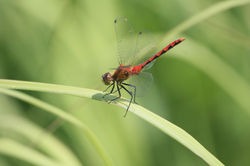 Odonate Dragonfly |


